Your cart is currently empty!
The Heritage & History of Tanilba Bay
Explore, discover & have fun!
The Heritage & History Trail of Tanilba Bay
Welcome to the Heritage and History Trail in Tanilba Bay, a journey through time that unveils the rich cultural tapestry of this coastal gem in New South Wales, Australia. As you explore this trail, you will step into the footprints of those who have shaped the narrative of Tanilba Bay, from its indigenous roots to the European settlers.
Nestled on the shores of Port Stephens, Tanilba Bay boasts a heritage that spans millennia. The trail invites you to discover the stories of the early European settlers who carved out a community against the backdrop of the picturesque bay.
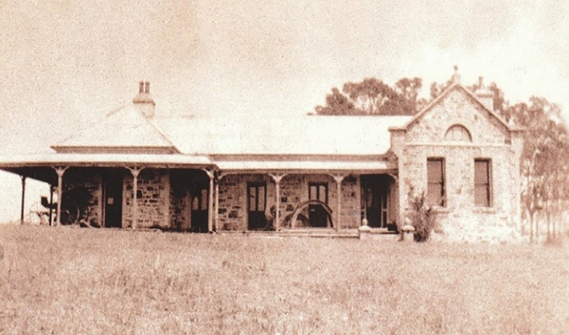
As you follow the trail through the streets, you’ll encounter landmarks that whisper tales of a bygone era. Tanilba House, with its timeless architecture, stands as a sentinel to the pioneering spirit of Lieutenant William Caswell, a retired naval officer who laid the foundations for this community. The convict-built walls and one of the oldest living olive trees in Australia bear witness to the resilience of those who shaped Tanilba Bay’s early foundations.


The Heritage and History Trail also introduces you to the urban planning vision of Henry F Halloran, whose contributions in the early 20th century shaped the layout of Tanilba Bay, including the picturesque stone Centenary, Water Gate, the Land Gate, The Summerhouse, The Changeroom and the Temple of the Stork. Each step you take is a passage through chapters of history, from the landscapes shaped by Indigenous hands to the suburban streets designed with meticulous care.
What’s so important about this trail?
Visitors, both local and from afar, share a common enthusiasm for delving into the history of the places they explore. Tanilba Bay, an iconic town, holds a distinctive charm as it unfolded in the post-World War I era. Paying tribute to this significant period, the town’s streets bear names that resonate with key figures from Australian and international World War I history.


Adding a unique touch, the street names also follow an alliterative pattern, (using the same sound at the begining of adjoining words e.g. Diggers Drive, Army Avenue) contributing to the town’s character and storytelling. Whether you’re a local or a tourist, discovering Tanilba Bay unveils a rich tapestry woven with historical significance and thoughtful design.


How does it work?
The History and Heritage Trail in Tanilba Bay employs a modern and interactive approach to engage visitors with the rich history of the area.
Information plaques are strategically placed at each site on street signs or posts, which serve as touchpoints for historical exploration.
Additionally, the incorporation of QR codes enhances the experience by providing a digital gateway to more in-depth information about each street name or site.
Here’s how the Heritage and History Trail works:

Physical Plaques
At key locations along the trail, physical information plaques are installed on street signs and posts. These plaques contain a link to a website where you discover concise details about the historical significance of the site, building, or landmark.
QR Codes & Digital Exploration
Each plaque features a QR code. You can use your smartphones or mobile devices to scan these QR codes. This action triggers a link to Port Stephens Family History Society’s website with content related to the specific site. This content includes extended historical narratives, archival photographs, audio-visual materials, or interactive elements.
Accessibility
The use of QR codes enhances accessibility, allowing visitors to engage with historical information at their own pace. Whether walking or driving the trail or exploring at a distance, individuals can access content in a way that suits their preferences.
Self-Guided Exploration
The Heritage and History Trail is a self-guided exploration, offering a flexible and immersive experience. Visitors have the freedom to choose the sites that interest them the most, and the digital content ensures a dynamic and enriching encounter with Tanilba Bay’s history.
Education and Engagement
This approach not only informs but also educates and engages visitors. The blend of physical plaques and digital interactivity caters to different learning styles and preferences, making the historical trail accessible and enjoyable for a diverse audience.
Incorporating QR codes into the History and Heritage Trail aligns with contemporary trends in heritage interpretation, leveraging technology to bring the past to life. It provides an innovative means for individuals to connect with Tanilba Bay’s history, fostering a deeper appreciation for the cultural heritage that defines the community.
Where Can I Acquire a Map of the Heritage & History Trail?
You can download a pdf of the map from the QR code on the lectern sign near the Centenary Water Gate or go to Port Stephens Family History Society website.
You can also acquire a copy of the map at the following places;
Port Stephens Council Website (Destination Port Stephens)
From the official website of Port Stephens Council. The council provides downloadable versions of trail maps, brochures, and tourist guides. Look for a “Heritage Trails” or “Visitor Information” section on the website.
Visitor Information Centre in Nelson Bay
Visit the Visitor Information Centre in Nelson Bay, which is a valuable resource for maps, brochures, and information about local attractions, including heritage trails. Staff at the information centre can guide you on the best way to explore our trail.
Contact Port Stephens Council
If you are unable to find the map online, consider reaching out directly to Port Stephens Council. They may be able to provide information or direct you to the appropriate resources.
Don’t forget to check your map!
Remember to verify the availability of the map, as resources and information may be updated or changed over time. Enjoy your exploration of the History and Heritage Trail in Tanilba Bay!
What will my exploation experience look like?
The 7 km Heritage and History Trail in Tanilba Bay offers a versatile experience, allowing visitors to explore either by walking or driving. The trail is designed for convenience, with direction arrows and informative signage at each site. Additionally, each sign includes approximate walking times, providing practical guidance for those on foot.
Here’s how the trail accommodates both walking and driving exploration:
Directional Arrows
Clear directional arrows guide explorers along the 7 km trail, ensuring that the path is easy to follow and helping travellers navigate from one site to the next.
Informative Signage
At each historical site, street signs or posts feature information plaques that offer insights into the site’s history. These signs serve as educational markers, allowing walkers to pause and learn about the heritage of Tanilba Bay.
Walking Times
Each sign includes approximate walking times to the next street or site. This information aids walkers in planning their journey, enabling them to allocate time for exploration and making the experience more enjoyable.
Car-Friendly Exploration
The trail is designed to be accessible by car, allowing individuals with limited mobility or those who prefer driving to experience the heritage and history of Tanilba Bay.
Whether walking or driving, the Heritage and History Trail is crafted to be an inclusive experience, ensuring that visitors can engage with the cultural heritage of Tanilba Bay in a way that suits their preferences and mode of exploration.